Bryce Canyon National Park Guide: Hoodoos and Hikes
Nomad Toolkit
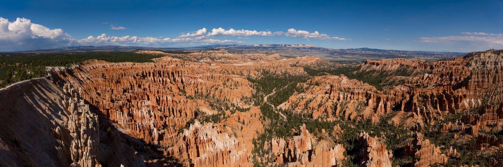
Bryce Canyon is not a canyon. The park sits on the Paunsaugunt Plateau in southern Utah at about 8,000 feet, and what you're looking at from the rim is the eastern edge of that plateau carved into tens of thousands of hoodoos, the tall orange-and-white rock spires the park is named for. The effect on first sight is disorienting in a good way. You expect canyon walls; instead the floor below you is packed with stone columns, arches, and fins for as far as you can see.
The park covers 56 square miles and receives around two million visitors per year, mostly from May through September. Get there in late April or early October and the crowds thin considerably. The rim sits above 8,000 feet on the north end and reaches 9,115 feet at Rainbow Point; that altitude keeps summer temperatures cooler than you'd expect for Utah, with highs typically in the mid-70s F at the rim and lows that drop to the low 40s even in July.
A Brief History
Scottish immigrant Ebenezer Bryce settled below the main amphitheater in the mid-1870s, sent by the LDS Church to put his carpentry skills to work in the Paria Valley. He grazed cattle among the hoodoos, reportedly called the place "a helluva place to lose a cow," and neighbors started calling it Bryce's Canyon. Paiute bands had lived in the region for centuries before him and called the hoodoos Anka-ku-was-a-wits, or "red painted faces." President Warren G. Harding established Bryce Canyon National Monument on June 8, 1923, and Congress upgraded it to Bryce Canyon National Park on February 25, 1928.
Getting There
The park is roughly 80 miles east of Cedar City, Utah, and about 270 miles from Las Vegas. The standard approach from Las Vegas is I-15 north to Cedar City, then US-89 east through Long Valley to UT-12 and UT-63 into the park. Total drive from Las Vegas is about 4 hours without stops. From Salt Lake City it's closer to 4.5 hours via I-15 south and US-89.
There's no commercial airport closer than Cedar City (CDC), which serves a handful of routes. Most visitors fly into Las Vegas (LAS) or Salt Lake City (SLC) and rent a car. A car is mandatory; there is no shuttle or transit from outside the park. Inside the park, a free shuttle system runs from mid-April through early October and covers all the major viewpoints and trailheads, which matters because parking lots at Sunrise Point and Bryce Point fill by 9 a.m. on summer weekdays.
Gas up in Panguitch or Tropic before entering. The park has no gas station. Panguitch is about 23 miles north on US-89; Tropic is 11 miles east on UT-12.
Entry and Costs
Standard vehicle entry is $35 for a 7-day pass. If you're visiting more than two or three national parks in a calendar year, the America the Beautiful annual pass at $80 pays for itself fast; it covers Bryce Canyon, Zion, Arches, Canyonlands, Capitol Reef, and every other NPS fee area.
Camping inside the park: North Campground (101 sites, open year-round) and Sunset Campground (100 sites, open May to mid-October) both run $20-$30 per night. Book on recreation.gov; summer weekends fill months out. The Lodge at Bryce Canyon (Wikipedia) is the only lodging inside the park and typically runs $250-$300/night in high season; book six months ahead if you want it. Outside the park, Panguitch has a half-dozen budget motels and a few Airbnbs at $80-$150/night. Tropic is closer to the entrance and has a couple of B&Bs worth checking.
Weather and When to Go
May through June: excellent. Wildflowers, good temperatures at the rim (60s-70s F), some lingering snow in shady canyon sections adding contrast to the hoodoos. Crowds are lighter than July and August.
July and August: peak season. Afternoon thunderstorms roll in around 2-3 p.m. and can drop lightning on the exposed rim fast. Start hikes early, be at a trailhead by 7 a.m. if doing anything longer than the Rim Trail, and plan to be back above the rim or inside your car by 1 p.m. Water in the slot canyon below Navajo Loop drains quickly but trail conditions can get muddy. Crowds are at maximum; shuttle use is essentially mandatory.
September and October: arguably the best months. Crowds drop noticeably after Labor Day, temperatures are ideal for hiking, and the aspen on the plateau start to turn in early October. The park stays fully operational through October.
November through April: fewer people, and the hoodoos with snow on them are genuinely spectacular for photography. The canyon hikes (Navajo Loop, Queen's Garden) can be icy and require traction devices on your boots from November through March. The Rim Trail stays accessible year-round. Sunset Campground is closed; North Campground stays open. Temperatures at the rim can hit single digits F overnight in January and February.
Best Hikes
The Navajo Loop and Queen's Garden combination trail (2.9 miles, 521 feet elevation gain) is the standard first-timer hike and earns that reputation. Descend via Wall Street on the Navajo Loop, a narrow slot between two 100-foot fins, then traverse through the hoodoo field to Queen's Garden, which has the densest concentration of the named formations, and loop back up to Sunrise Point. Do it counterclockwise: start at Sunset Point, exit at Sunrise. The shuttle connects them. Allow two hours at a comfortable pace.
Fairyland Loop (8 miles, 1,750 feet) is the hardest main trail and the quietest. It starts at Fairyland Point, which is north of the visitor center and off the main shuttle route, so you'll drive there and have the trailhead mostly to yourself. Full day hike; bring four liters of water minimum.
The Rim Trail runs 11 miles along the canyon edge and is nearly flat. Pick any section. The stretch between Sunrise and Inspiration Points (1.5 miles) has the best density of views for the least effort.
Tower Bridge (3 miles round-trip from North Campground trailhead) is worth the detour for the natural arch formation at the turnaround point. Less-trafficked and good for afternoon light.
Viewpoints
Bryce Point gives the widest panorama of the amphitheater and is the most photographed. Inspiration Point has multiple tiers and a slightly closer view of the Silent City formation. Sunrise and Sunset Points are directly connected to the main shuttle stops and are often crowded but still worth five minutes each. Rainbow Point at the south end of the scenic drive (18 miles from the visitor center) has bristlecone pines and a quieter atmosphere; the views extend to the Kaiparowits Plateau.
Connectivity and Cell Coverage
Cell coverage inside the park is essentially nonexistent. The visitor center area has a sliver of AT&T signal on a good day; nothing reliable for data. The lodge has guest WiFi but doesn't advertise speeds publicly, and it's not set up for work sessions.
Panguitch, 23 miles north on US-89, has adequate Verizon and AT&T coverage in town. The Panguitch Public Library (25 S 200 E) has public WiFi. Tropic is smaller but has coverage near the main intersection. For anything requiring a real connection, Cedar City 80 miles west has fiber-served coworking and fast hotel WiFi.
Food and Supplies
Inside the park: the lodge restaurant is open for breakfast, lunch, and dinner during the season; quality is decent for a national park captive audience, prices are park-lodge prices ($18-30 for an entree). The General Store near Sunrise Point stocks basic camp supplies, snacks, and sandwiches.
Panguitch has a grocery store (Bryce Canyon Pines store and a small market), a handful of diners, and a Subway. Nothing remarkable but adequate for resupply. Tropic has a couple of sit-down restaurants that are solid for the area.
For a proper meal before or after the park, Kanab (1 hour south on US-89) has multiple restaurants including Peekaboo Canyon Wood Fired Kitchen, which is genuinely good and worth the drive.
Digital Nomad Corner
Bryce Canyon is a reset destination, not a work base. You're at 8,000 feet with no connectivity inside the park, which is fine if you treat the visit as a 2-3 day unplugged stretch. The gateway towns don't have coworking infrastructure.
The practical setup: check into an Airbnb in Panguitch or Tropic on a Thursday night, work Friday morning from the accommodation or the library in Panguitch, then go deep into the park for the weekend, and drive back to a city with connectivity on Monday. Cedar City (80 miles) and St. George (160 miles southwest) are both viable remote work towns if you need to tack on work days around a Bryce visit. St. George in particular has a growing infrastructure of coffee shops with reliable WiFi, fast-casual coworking spaces, and good Airbnb stock.
Pack everything you need before you enter the park. A portable battery bank is useful since charging options in the canyon are limited and parking lot stays between hikes can be long. Download maps offline before arrival; Google Maps and AllTrails both have offline mode. The NPS app has downloadable park maps that include trail detail.
Practical Notes
Sun protection at 8,000+ feet is serious. The UV index at altitude hits levels that will burn you quickly even on partially overcast days. Bring SPF 50 and reapply. The thin air means exertion on uphill sections feels harder than sea-level hiking at the same pace; the canyon descents are easy but coming back up the switchbacks at altitude surprises people who underestimate it.
Wildlife: mule deer are common near the campgrounds and trailheads at dawn and dusk. Utah prairie dogs have a colony near the visitor center. Ravens are everywhere. Mountain lions are present but rarely seen. Store food in your car, not in tents.
The park entry fee covers the scenic drive, which runs 18 miles from the visitor center to Rainbow Point with 13 marked overlooks. If your time is limited and your knees aren't up for canyon descents, the scenic drive alone is worth the entry fee.
Where I Stayed
I stayed at Glamping Cabin #35 near Bryce Canyon by Bryce Canyon Shadows, a glamping property about 10 minutes north of the park entrance on Highway 89 in Panguitch. Good base with cabin-style accommodations and easy morning access to the park before crowds arrive. View on Google Maps.
Keep planning: Brighton: England's Seaside City, European Train Travel for Digital Nomads and Acadia National Park Guide: Maine's Coastal Peaks.